Summary
A major, 2+km long EM anomaly has been identified in the southern portion of the Pearson property. To the north, on the Mach claims, prospecting in 2017 disclosed a 1km long area containing malachite and azurite stain. An airborne Geotech ZTEM survey was commissioned over part of the property by Teuton in 2018, resulting in the discovery of several target zones. Limited drilling carried out in the same year did not reach target depths.
The Pearson and adjoining Mach claims lie about 20 km to the south-southwest of Seabridge Gold’s prolific KSM property, home to the world’s largest reserves of copper and gold.

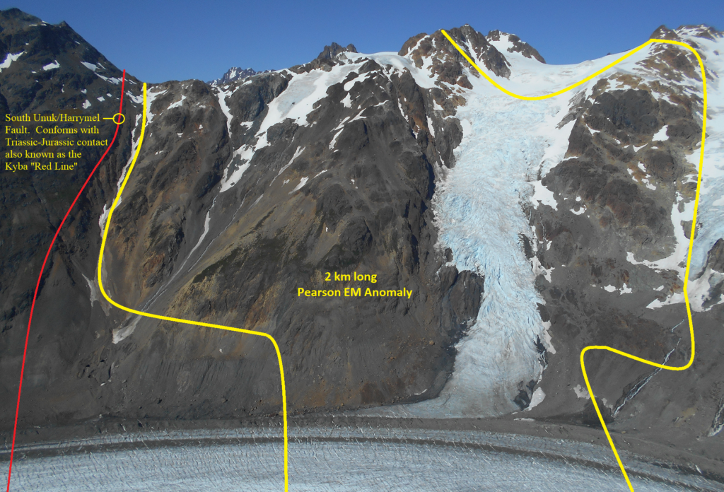
The former Granduc copper mine, British Columbia’s 2nd largest Besshi deposit after Windy Craggy, is situated 2km to the southwest. Garibaldi Resources’ E&L nickel prospect, subject of intense exploration interest in 2017 and 2018, lies 38km to the northwest along the path of the South Unuk/Harrymel Fault (which coincides with Kyba’s “Red Line”). Both Garibaldi’s E&L property and Teuton’s Pearson property lie within gravity highs (see Fig. entitled Gravity Anomaly Map).
Teuton presently owns a 100% interest in the Pearson and adjoining Mach claims. Management is currently seeking an option partner for this property.

Geophysical Anomaly
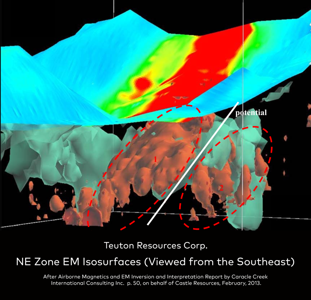
In early 2013 the previous owner of the Pearson property (Castle Resources) had an independent consulting company (Caracle Creek International Consulting) model and interpret a series of EM anomalies on the Pearson property as defined by a 2010 airborne survey. The resulting work identified a major, 2+km long target—see accompanying figures.
Castle stated the following in their Feb. 2013 news release.
“An extensive conductor has been identified along the southern face of the area roughly 3.5 km north east of the JK Zone** (termed the North EM Conductor). This feature trends north-south, exhibits a conductivity greater than 13 mS/m and extends over a strike length exceeding 2 km, dipping approximately 15 degrees to the south. This feature extends to surface at location (NAD 83 UTM Zone 9) 419235 E, 6234560 N, and the majority of the feature begins 200 m below surface, representing a potential near-surface drill target. This conductive feature is located within a magnetic low and bounded to the east by a magnetic high (0.01 nT).
The target was scheduled for drilling by Castle in 2013 but due to circumstances this never took place. In 2015, 100% ownership of the Pearson property reverted to Teuton
[Readers are cautioned that Teuton’s Qualified Person, D. Cremonese, P.Eng., has not independently verified either the collection of the geophysical data or the modelling/interpretation of it. However, he has no reason to believe that it is not reliable. As President of Teuton Resources, Mr. Cremonese is not independent of the Company.]
New Area of Green/Blue Copper Stain
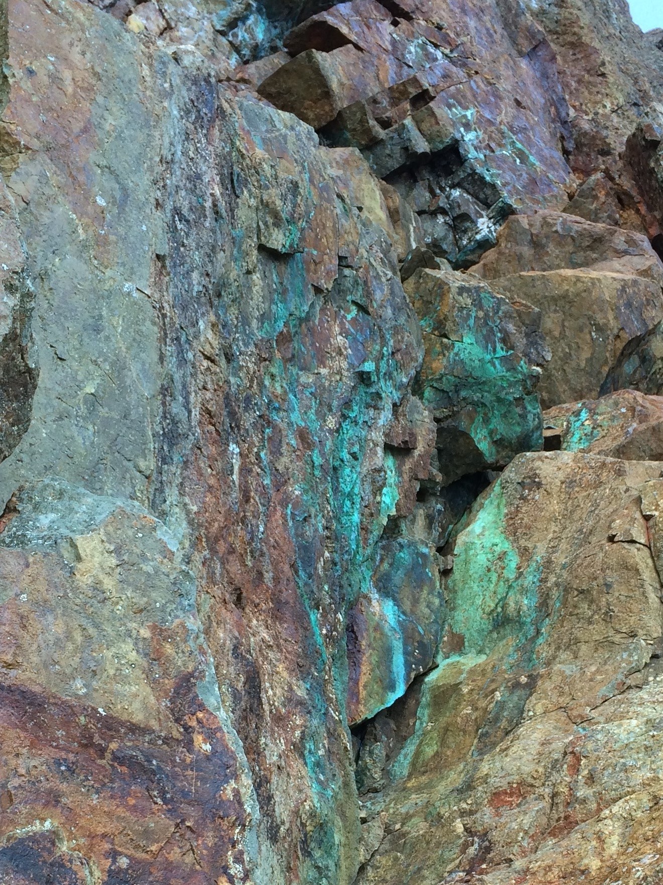
Prospecting carried out in 2017 to the north of the Pearson property resulted in the discovery of a kilometer long zone carrying numerous instances of green-blue, malachite and azurite stain (see picture gallery, below). One of the prospecting geologists stated:
“It is very encouraging that the malachite and azurite is found on the cliff faces for a straight distance of about 1km, ending at an ice field in the NW and a glacier in the SW. These are not only a few occurrences, but staining shows in many places. Sometimes only small spots, but also large patches that can be seen from 200m away. Mineralization is tied to fracture fillings and disseminations in wall rock as well as quartz veining.”
Local veins and breccia occurrences have carried gold values running from trace to 68.7 g/t gold. Alteration patterns suggest that this area may represent the top of a porphyry copper system. Current plans calls for a ZTEM survey to be flown over the region which may help in defining whether or not a porphyry system is present.